Pattern of Attacks in East Sacramento
Sept 16, 2017 4:35:37 GMT
slumbergirl, jackydee, and 8 more like this
Post by Any of N on Sept 16, 2017 4:35:37 GMT
All that great work done with Geographic Profiling shouldn't stop us from looking at the attack patterns ourselves. There may be characteristics in the clusters that the math fails to take into account. With that in mind, consider the following circumstances in regard to East Sacramento:
A lot of the speculation regarding the EAR's base of operations concerns there being two: one north and one south. For now let's consider the possibility that there was only one. Where might it have been?
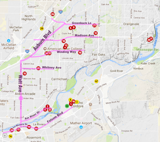
Here is an annotated map, similar to one I posted in another thread which is again based on the FBI's map.

This map imagines EAR using Watt and Auburn as his main thoroughfares, and he laterals off from there to select targets. If his base is somewhere near Watt and Arden Way, then he benefits from a series of simple routes. (Roads highlighted in magenta.)
Consider, for example, Attacks 1 and 2 on either side of the river. He simply goes south on Watt and turns east in both instances. The routes are similar with one taking longer. With the attacks on La Riviera added, a southward diagonal pattern results. If the EAR takes east-west roads intersecting Watt and Auburn as highlighted, a northward diagonal pattern is also a natural consequence. These pathways also facilitate the practices of alternating river sides and suburbs on consecutive attacks.
One thing it doesn't do is explain the large tight cluster in Rancho Cordova. Yet it doesn't preclude it, either.
I offer this up as merely one possibility. Others have made similar observations in the past, but I hope the map makes it clear. The Watt-Auburn approach would have made things simple for the EAR to reach all the attack sites from a single base. It also leads me to the question -- has anyone looked along Watt Ave in Arden-Arcade for potential POI's?
- The attacks northward scatter roughly in a southwest-northeast diagonal pattern.
- The attacks southward do so as well, generally following the American River.
- There are two tightly packed clusters on either side of Riverbend Park, with six attacks in Rancho Cordova and three across the river in
La RivieraCarmichael. There were no bridges in the immediate area at the time. - The EAR liked to jump the river in consecutive attacks, doing so with few exceptions during the first 19 opportunities.
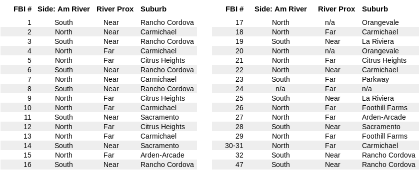
- The EAR never hit within the same suburb or "census-designated area" for two consecutive attacks. (The icons numbered 30 and 31 represent two victims for one attack.) Again, we're talking about East Sacramento only.
A lot of the speculation regarding the EAR's base of operations concerns there being two: one north and one south. For now let's consider the possibility that there was only one. Where might it have been?
Here is an annotated map, similar to one I posted in another thread which is again based on the FBI's map.

This map imagines EAR using Watt and Auburn as his main thoroughfares, and he laterals off from there to select targets. If his base is somewhere near Watt and Arden Way, then he benefits from a series of simple routes. (Roads highlighted in magenta.)
Consider, for example, Attacks 1 and 2 on either side of the river. He simply goes south on Watt and turns east in both instances. The routes are similar with one taking longer. With the attacks on La Riviera added, a southward diagonal pattern results. If the EAR takes east-west roads intersecting Watt and Auburn as highlighted, a northward diagonal pattern is also a natural consequence. These pathways also facilitate the practices of alternating river sides and suburbs on consecutive attacks.
One thing it doesn't do is explain the large tight cluster in Rancho Cordova. Yet it doesn't preclude it, either.
I offer this up as merely one possibility. Others have made similar observations in the past, but I hope the map makes it clear. The Watt-Auburn approach would have made things simple for the EAR to reach all the attack sites from a single base. It also leads me to the question -- has anyone looked along Watt Ave in Arden-Arcade for potential POI's?


